New System Uses Sensors and Satellite Imaging to Track Vessels in Real Time
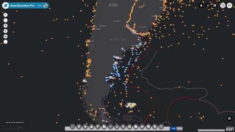
REDLANDS, Calif. — (BUSINESS WIRE) — September 26, 2018 — Esri, the global leader in location intelligence, today announced that Prefectura Naval Argentina and Aeroterra S.A. have partnered to implement Esri's ArcGIS platform for a real-time tracking system The new system, called Guardacostas Pro, uses a combination of satellite imaging and signal processing to monitor vessels for illegal activities such as drug smuggling and fish poaching in the coastal waters of Argentina’s exclusive economic zone (EEZ).
This press release features multimedia. View the full release here: https://www.businesswire.com/news/home/20180926005209/en/

Esri announces that Prefectura Naval Argentina and Aeroterra S.A. have partnered to implement Esri's ArcGIS platform for a real-time tracking system. (Photo: Business Wire)
As Argentina's coast guard, Prefectura Naval deploys patrol vessels, helicopters, and airplane spotters to protect its economic interests and to guard against the decline of its fishery. This year, the Guardacostas Pro system allowed Prefectura Naval to track a Spanish vessel that entered the EEZ and attempted to return to international waters. The coast guard was able to catch the ship, which had poached roughly $380,000 worth of fish; escort it back to port; impound it; and fine the crew. The captain had little ground to refute the charges because the coast guard had the data to prove the illegal activity.
"As of five years ago, we had very little information about the use of our seas," said Ernesto Miguel Klocker, Prefectura Naval director of informatics and communications. "Now we have a good picture, which gives us electronic control of the sea, allowing us to send our air and naval units directly to the places where ships operate."
Until recently, its primary enforcement tool was constant patrolling and investigation of all ships. Now Guardacostas Pro monitors signals that every vessel transmits to avoid collision and to provide data on vessel type, speed, and location. It combines this with satellite imaging and Esri's spatial analytics capabilities to give coast guard personnel real-time alerts when a vessel is entering their waters.
"Prefectura Naval is setting a truly cutting-edge example of a forward-thinking organization," said Dean Angelides, Esri head of international alliances and partners. "The best way to effectively enforce laws over such a large scale as the EEZ is to know exactly where things are happening and when, and Argentina is now leading the way in data-driven public safety."
After being successfully proven at sea, the Guardacostas Pro system has been moved ashore and is now a multiagency tool to aid Argentina's Ministry of Security's homeland security mission. The Ministry of Security will use the system to track and locate its operative units through mobile phones, radio equipment, vehicles with location sensors, and search and rescue aircraft.
To learn more about how Esri supports public safety with enhanced situational awareness, visit go.esri.com/PublicSafety.
About Esri
Esri, the global market leader in geographic information system (GIS) software, offers the most powerful mapping and spatial analytics technology available. Since 1969, Esri has helped customers unlock the full potential of data to improve operational and business results. Today, Esri software is deployed in more than 350,000 organizations including the world's largest cities, most national governments, 75 percent of Fortune 500 companies, and more than 7,000 colleges and universities. Esri engineers the most advanced solutions for digital transformation, the Internet of Things (IoT), and location analytics to inform the most authoritative maps in the world. Visit us at esri.com.
About Aeroterra
Aeroterra S.A. is a technology company specializing in the implementation of geographic information systems and related geospatial techniques. Since its creation in 1973, the company has been recognized as the leading provider of geospatial services in Latin America and ISO 9001 certified since 2008.
Since 1989, Aeroterra has been the only authorized company to distribute and support the Esri ArcGIS platform in Argentina and Uruguay. In November 2016, Aeroterra became part of the Esri Global Support team, providing services to more than 1,000 users in its region. The company provides geocentric solutions, including GIS software; image processing; digital photogrammetry; system integration; geodatabase design; process reengineering; server, desktop, mobile, and web application development; training; and support. In addition, Aeroterra is responsible for maintaining a network of national and international partners as part of the Esri Partner Network (EPN), whose members are leaders in their respective fields. Visit us at https://www.aeroterra.com.
Copyright © 2018 Esri. All rights reserved. Esri, the Esri globe logo, ArcGIS, The Science of Where, esri.com, and @esri.com are trademarks, service marks, or registered marks of Esri in the United States, the European Community, or certain other jurisdictions. Other companies and products or services mentioned herein may be trademarks, service marks, or registered marks of their respective mark owners.
View source version on businesswire.com: https://www.businesswire.com/news/home/20180926005209/en/
Contact:
Esri
Karen Richardson, 914-841-3180
Public Relations
Email Contact