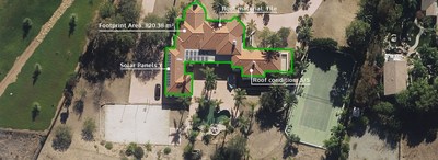
"Advanced classification on our high-resolution aerial imagery is needed more than ever before," stated Erik Jorgensen, CEO of Vexcel Group. "We've been growing our aerial imagery coverage globally and are now applying machine learning to our already highly accurate imagery to analyze buildings and deliver information on a whole new level and scale. This helps our customers make better decisions with greater confidence, whether it's an insurer using these details to underwrite a policy or property assessors performing more accurate desktop assessment, there's endless opportunity for enhancing workflows and decision-making. We strongly believe in the value of detailed information that can be derived from the highest quality imagery; Elements: Building Attributes makes this turnkey for our customers."
Building Attributes is the latest addition to Vexcel's Elements product line which includes Property Attributes and Damage Assessment. The data provided is created and derived from Vexcel's urban area collection program (25+ countries) and wide area collection program, which also includes rural areas (20+ countries). Vexcel's award-winning UltraCam sensors are calibrated to collect the highest accuracy of imagery quality and positioning in the market, resulting in highly detailed building outlines and attributes for improved visualization and analysis. The building and roof attributes are automatically calculated and available to users via Vexcel's API and web-based application, Viewer.
Valuable Building Insights in Seconds
Starting with location coordinates, a user can request building attribute information for the closest building or structure. Users have immediate access to a building's footprint area, ground elevation, roof condition, roof shape, roof material, defensible space metrics, and many other useful pieces of data.
Examples of how multiple industries could benefit from this information include:
- Smart Cities – project planners can use the building geometry to create more accurate 3D models
- Telecom – network designers can map clean lines-of-sight to reduce signal interference between transmitters
- Insurance - risk analysts can perform better wildfire risk reviews using defensible space information
- Real Estate – realtors can validate building features and benefits when listing a property
- Property Assessment – tax assessors can remotely evaluate buildings and track changes or improvements to homes for updating tax rolls
- HD maps – map engineers can verify building locations to map expanding neighborhoods, validate UAV delivery service coordinates, and support more accurate autonomous vehicle mapping
To learn more about this product and see the full list of building attributes available, visit vexceldata.com/elements.
More Info
Vexcel collects the largest aerial program on the planet, delivering data at a resolution, clarity, and accuracy that's never been delivered on a global scale. Its robust library of geospatial data helps a variety of industries, such as Government, Telecom, Utilities, Insurance, AEC, Energy and more.
About Vexcel Data Program
For 30 years, Vexcel has been the industry leader in the photogrammetric and remote sensing space, providing a comprehensive library of cloud-based geospatial data. Vexcel's unique technology stack results in unrivaled image quality, helping customers streamline remote assessment, innovate common workflows, and enhance decision-making with confidence. Vexcel captures aerial imagery and geospatial data in 25+ countries, including US, UK, Canada, Australia, Japan, and across Western Europe. More at vexceldata.com.
Photo - https://mma.prnewswire.com/media/1856086/Vexcel_Data_Program_building_attributes.jpg
| Contact: |
| Company Name: Vexcel Data Program
Kris Wagner Email Contact |


