Company uses AI and geospatial imagery to provide wildfire-related property information to insurers, reinsurers, and CAT risk providers
MOUNTAIN VIEW, Calif. — (BUSINESS WIRE) — April 3, 2019 — Today, Cape Analytics is announcing a new defensible space solution that allows home insurance carriers to systematically assess wildfire vulnerability for properties across the U.S. The defensible space solution provides information about vegetation clearance and fuel load within the home ignition zone, critical factors in evaluating wildfire risk. Cape Analytics is leveraging AI and geospatial imagery to provide an industry first: defensible space data across the United States at the individual property level.
This press release features multimedia. View the full release here: https://www.businesswire.com/news/home/20190403005804/en/

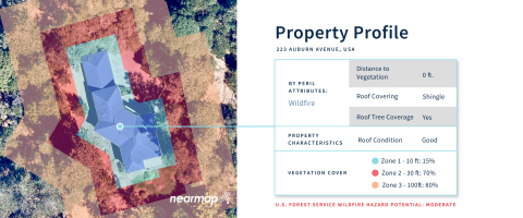
Cape Analytics' defensible space solution provides information about vegetation clearance and fuel load for individual properties. (Graphic: Business Wire)
Wildfires have ravaged North America over the past few years. With a 41 percent increase in the number of homes built in the wildland-urban interface between 1990 and 2010, loss of life and insured losses have skyrocketed. In 2018 alone, wildfires killed 104 people and caused $12.3 billion in direct insured losses in California, according to the California Department of Insurance. According to agencies like CAL FIRE and the National Fire Protection Association (NFPA), maintaining defensible space -- the distance between a building and surrounding vegetation -- is a key component in reducing the risk of property damage. California laws and the NFPA both require defensible space in areas prone to wildfire, but property inspections are challenging to enforce at scale. Moreover, the California Department of Insurance (CDI) highlights that existing wildfire risk scoring tools are not accurate enough or “granular enough to objectively identify fuel sources and other physical characteristics, and do not take into account mitigation done by the homeowner or community.”
Now, Cape Analytics is using advanced computer vision technology and high-resolution imagery to offer a new defensible space solution to U.S. insurers and wildfire agencies. This solution is complementary to leading wildfire risk models and scoring tools, while addressing the need called out by the CDI and wildfire agencies. The information available through this new solution is crucial to those on the frontlines, from insurers to homeowners to wildfire response teams.
Cape Analytics now provides first-of-its-kind wildfire intelligence, including:
- Distance to nearest vegetation, most critical in the zone immediately surrounding the structure which should be free of all tree limbs and fire-prone vegetation.
- Surrounding fuel load calculations for individual homes and whole neighborhoods, with multiple radial zones to score property fuel density.
- Granular detection of property vegetation and structure rooftop perimeter, using 6 cm resolution aerial imagery across the continental U.S.
- Integration of contextual USDA Forest Service Wildfire Hazard Potential scores.
“Delivering a unique, location-specific understanding of fuel loads around a property precipitates the next leap in understanding wildfire risk and defensible space at the most granular level,” said Kevin Van Leer, Client Solutions Manager at Cape Analytics. “Cape Analytics is building on the industry’s recent technological strides in response to major events, such as explicit ember transport in catastrophe models as well as updated hazard scores. The suite of wildfire tools now available better address traditional underwriting, rating, and portfolio management.”
To learn more about Cape Analytics’ wildfire product, visit www.capeanalytics.com.
About Cape Analytics
Cape Analytics uses AI and geospatial imagery to provide instant property intelligence for buildings across the United States. Cape Analytics enables insurers and other property stakeholders to access valuable property attributes at time of underwriting—with the accuracy and detail that traditionally required an on-site inspection, but with the speed and coverage of property record pre-fill. Founded in 2014, Cape Analytics is backed by leading venture firms and innovative insurers and is comprised of computer vision and risk analysis experts.
View source version on businesswire.com: https://www.businesswire.com/news/home/20190403005804/en/
Contact:
Kayvan Farzaneh
Cape Analytics
Email Contact


